For an adventurous day in New York, provided the weather is nice, try combining the ends of two NYC Ferry routes, Soundview (SV) in the Bronx with the Rockaway (RW) route in Queens. An excursion from the Bronx waterfront south to the sandy shores of Rockaway becomes a great moving panorama of the metropolis.
 |
| The beginning - near the Soundview landing in the Bronx |
Many New Yorkers have grown so accustomed to getting around by subway that seeing the city like the tourists may come as something of a shock. Being practical sorts, they’ll point out that a NYC Ferry ride costs the same as a subway ride - $2.75 (!) but with perks such as a well-stocked snack bar, comfortable seats, and views of their city’s famous skyline. Plus, there’s something relaxing about a boat ride that the A train, for example, can’t seem to accomplish. So, the experience comes as a happy shock.
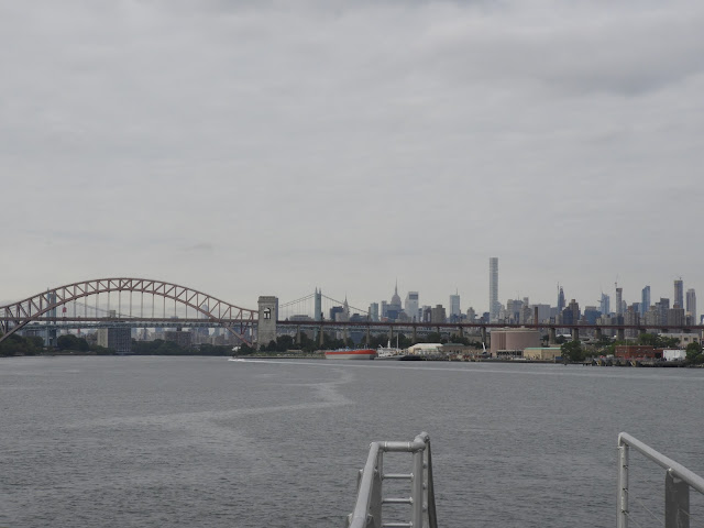 |
| Hell Gate Bridge and the Manhattan skyline |
To begin this epic north-south trip on the water, start at the Soundview landing in the Bronx. An initial ferry ride may be necessary to get there, so the adventure will start even earlier. From Soundview, you’ll sail down to Pier 11/Wall Street, with stops along the way at the E 90th Street and E 34th Street landings. The trip should take around 30 minutes. At Wall Street, transfer to the Rockaway route for the remainder of the Bronx-Queens adventure. This second route is longer, close to 55 minutes, but you could wind up on a nice beach facing the Atlantic Ocean.
 |
| Triborough Bridge with Randall's Island |
Much of this trip becomes a lesson in New York geography, so a map comes in handy for review. The ride begins at Soundview where Westchester Creek meets the East River and continues south to the waters near North Brother Island and Rikers Island. La Guardia Airport can be seen in the distance to the south.
 |
View of the abandoned hospital on North Brother Island.
The off-limits island is now a bird sanctuary. |
It’s a highly industrialized area here, but not without great beauty and several historical curiosities. For example, look for the decaying ruins of the abandoned smallpox (and other deadly diseases) hospital on North Brother Island, an island now only inhabited by birds. In fact, the ferry trip provides excellent opportunities for birdwatching, especially on the tiny islands along the way.
 |
A woman waves from the walkway above the FDR.
The ferry route is so novel at this point that people on shore may wave to passengers on the boat.
Also, ferry passengers sitting on the top deck often wave to other passing ferries. |
Between Randall’s Island Park and the Con Ed Power Plant, we go sailing under the Hell Gate Bridge and the Triborough Bridge and over to the East 90th Street landing in Manhattan’s Yorkville neighborhood near Gracie Mansion and Carl Schurz Park. A few passengers get on and off. I began my initial adventure on a weekday morning at this landing. Uptown residents can take the crosstown M86 route for easy access to the landing.
 |
| The Queensboro Bridge |
Continuing south, the ferry hugs close enough to the eastern shore of Manhattan for excellent starboard views of riverfront architecture. On the port side, Roosevelt Island laterally unfolds underneath the Queensboro Bridge, affording good views of the trams, the
new buildings at Cornell Tech, the ruins of the old smallpox hospital (now the second abandoned hospital seen on the ride) and the FDR Four Freedoms Park at the south end. Over on the Manhattan side, the ferry rides by the United Nations complex.
 |
| Passing under the Brooklyn Bridge, with the Lower Manhattan skyline |
South of E. 34th Street, the ferry passes underneath the Williamsburg, Manhattan, and Brooklyn Bridges before arriving at the busy Pier 11/Wall Street landing. While chatting with two fellow passengers about the various passing bridges and buildings, we talked ourselves into boarding the next ferry to Rockaway to continue the adventure. What the heck, right? Let’s see how far two inexpensive New York ferry rides can take us, especially if there’s sun and sand at the end.
 |
| The adventure continues on the larger ferry, Ocean Queen Rockstar, for the Rockaway route. |
We boarded Hornblower’s new 350-seat ferry brought into service for the popular Rockaway route. The boat sails past the skyline of Lower Manhattan, the Battery, and the occasional Staten Island Ferry and out into the Upper Bay, cruising past and around the western shores of Governor Island. The ferry then curves around Red Hook and into the Bay Ridge Channel where it stops for passengers at the Brooklyn Army Terminal. (At certain times, Rockaway routes will skip this stop).
 |
| Approaching the Verrazano-Narrows Bridge |
After crossing under the Verrazano-Narrows Bridge into the Lower Bay, the ferry continues east and parallel to Coney Island, Brighton Beach, and Manhattan Bridge. Into the Rockaway Inlet, the ferry travels between Floyd Bennett Field on the north and western sections of the Rockaways - Breezy Point, Rockaway Point, and Roxbury - to the south.
 |
| Parachute Jump, Coney Island, as seen from the ferry |
Passing closely under the Marine Parkway Bridge, the boat then steers into Jamaica Bay for a final approach to the channel side of the Rockaways. The control tower at JFK Airport can be seen in the distance, providing a nice bookend with LaGuardia Airport at the beginning of the trip.
 |
| The view from the ferry and the Marine Parkway Bridge in the distance |
At the end of the ride, my travel companions agreed that it was amazing to see places like Coney Island from the water, normally seen from up close, and that we would take this trip again in a heartbeat and at night.
 |
| On dry land at the Rockaway Boardwalk |
The Rockaway ferry landing is located near the intersection of Beach Channel Drive and Beach 108th Street. All that’s left now on the trip is a quick check of the return schedule and a short walk to the beach. Caracas Arepa Bar, a longtime favorite beach hangout, is nearby.
 |
| Waiting for the return trip at the Rockaway landing |
After an enjoyable hour at the beach, I took the ferry back to Wall Street and transferred to the Soundview ferry to East 90th Street. After a crosstown ride on the M86 bus to Broadway and then the 1 train back to Northern Manhattan (and back to life underground), I managed to be home by 4:30 p.m. (Amazing!) I was a little tired and windblown, quite understandable after a day spent on a boat and at the beach. I got a little too much sun, as I would learn later. Still, I can’t wait to make this trip again and even in the colder months, except for maybe the walk on the beach.
 |
| The skyline in the distance |
For many New York commuters, the option to take the ferry from home to work and back again may feel like a luxury in comparison with the subway system, especially in the heat of the summer. In addition to the comfort of the ride, the experience of traveling by water changes the everyday experience of living in the city. It’s like putting together all of the little pieces in a jigsaw puzzle, previously sealed in a box underground, and suddenly seeing the big picture.
 |
| Map of NYC Ferry Routes at the Rockaway landing. Notice the beginning and endpoints of this adventure. |
Furthermore, the experience of traveling by water over a large geographical area is far more complex than indicated on the official travel maps. The maps used by NYC Ferry, like those of the MTA, are streamlined for simplicity and easy reading, but the visual experience that unfolds over a sequence of ferry trips is akin to binge-watching a New York miniseries.
For those new to the city ferry system, please read the post,
A Beginner’s Guide to Riding the NYC Ferry.
In a recent press announcement, city officials indicated that NYC Ferry ridership could grow to as many as 9 million annual passengers by 2023, effectively doubling their initial expectations.
Resources:
•
NYC Ferry official website
Images by Sailing Off the Big Apple from August 21, 2018. Clicking on the images enlarges them.


